In today’s fast-changing world of maritime navigation, picking the right Marine Inertial Navigation System really matters if you want your positioning to be spot-on and your operations to run smoothly. As tech keeps advancing and pushing the limits of what these systems can do, it’s super important to understand how to choose one that actually fits your specific needs. Like industry expert Dr. John Stevens from the Marine Navigation Institute reminds us, "The right Marine Inertial Navigation System can seriously boost your vessel’s accuracy and maneuverability—making everything safer and more efficient in the long run."
Navigating today’s complex maritime environment isn’t a simple task, and selecting the right system calls for some careful thought. Things like the type of vessel you're using, the conditions you’ll encounter, and the features you really need all come into play here. With ships facing everything from tricky weather to new tech demands, getting a handle on these factors helps folks make smarter choices suited to their unique situations.
At the end of the day, choosing a Marine Inertial Navigation System isn’t just a technical decision—it’s a strategic one that can directly impact how safe and effective your operations are. Taking the time to pick wisely means your vessels can navigate with real precision, stay ahead with the latest tech, and meet the ever-changing needs of the marine industry.

Factors Influencing the Selection of Marine Inertial Navigation Systems
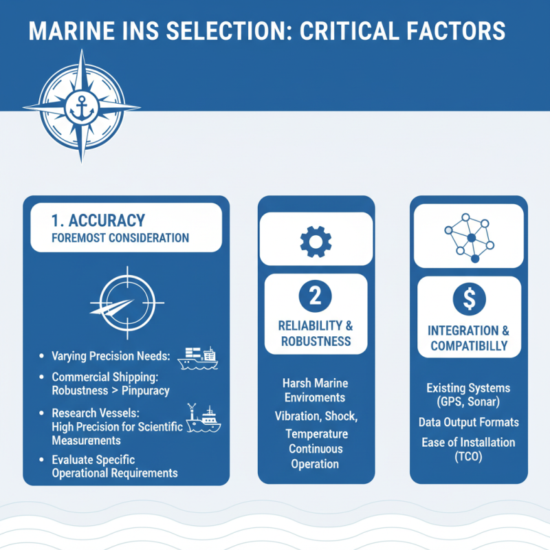
When selecting a marine inertial navigation system (INS), several critical factors come into play that can significantly influence your choice. One of the foremost considerations is the accuracy of the navigation system. Different applications and vessels require varying levels of precision; for instance, commercial shipping might prioritize robustness over pinpoint accuracy, while research vessels may need high precision for scientific measurements. Therefore, it is essential to evaluate the specific accuracy requirements for your operations.
Another crucial factor is the environmental conditions in which the navigation system will operate. Marine environments can be harsh, with varying temperatures, humidity levels, and exposure to saltwater. A system that can withstand these conditions without degrading in performance will be vital for ensuring reliable navigation. Furthermore, the size and type of the vessel play a role in the system selection. Larger ships may require more complex systems capable of integrating additional sensors, while smaller vessels might benefit from simpler, more cost-effective options. By carefully assessing these factors—accuracy, environmental resilience, and vessel specifications—you can better determine the right inertial navigation system for your maritime needs.
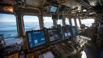
Understanding Different Types of Marine Inertial Navigation Technologies
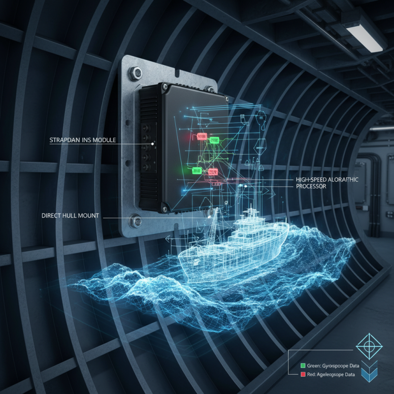
When selecting a marine inertial navigation system, it is crucial to understand the various types of technologies available. The two primary categories of marine inertial navigation systems are strapdown and gimbaled systems. Strapdown systems utilize solid-state sensors that are directly mounted to the vessel, making them lighter and more compact. They rely on sophisticated algorithms to process data from accelerometers and gyroscopes, enabling accurate position tracking even in turbulent conditions. This type is ideal for smaller vessels or applications where space and weight are a concern.
On the other hand, gimbaled systems maintain a level reference using a system of rings and platforms; they are often used in larger ships or submarines where precise navigation is critical. These systems provide continuous stabilization, allowing for high accuracy over extended periods. However, they can be heavier and more complex than strapdown systems. Understanding the operational requirements, environmental conditions, and specific navigation needs of your marine application will help you choose the right technology that balances accuracy, efficiency, and cost.
Key Specifications and Performance Metrics for Marine Navigation Systems
When selecting a marine inertial navigation system (INS) for your specific needs, it is crucial to focus on key specifications and performance metrics that directly impact navigation precision and reliability. One of the foremost specifications to consider is the system's accuracy, typically measured in terms of position accuracy (in meters) and velocity accuracy (in knots). According to industry research, high-performance marine INS can achieve position accuracy within 1-2 meters over extended durations, which is critical for applications such as underwater exploration and autonomous vessel operations.
Another vital metric is the system's update rate, which affects how frequently the INS provides navigational information. An optimal update rate for marine applications ranges from 10 Hz to 100 Hz, depending on the operational requirements. A higher update rate allows for real-time adjustments and enhances the system's ability to handle dynamic marine environments. Additionally, look for systems that offer robust environmental compensation features, as these components significantly minimize errors caused by factors such as temperature variations or vessel motions.
**Tips:** When assessing marine INS, prioritize systems that feature built-in redundancy to ensure continuous operation. Also, consider solutions with advanced integration capabilities for seamless compatibility with existing marine platforms and other navigational aids. Investing in a system with user-friendly interfaces and comprehensive support will facilitate smoother operations on board.
2025 How to Choose the Right Marine Inertial Navigation System for Your Needs
| Specification |
Description |
Performance Metric |
| Position Accuracy |
Typical horizontal accuracy in nautical miles |
0.002 - 0.05 NM |
| Update Rate |
Frequency of navigation updates per second |
1 - 100 Hz |
| Operating Range |
Effective distance without signal loss |
Up to 4000 NM |
| Integration Capability |
Ability to integrate with other systems (e.g., GPS, AIS) |
Yes/No |
| Gyro Type |
Type of gyro used (e.g., Fiber Optic, Ring Laser) |
Fiber Optic/Ring Laser |
| Power Consumption |
Amount of power required for operation |
10 - 50 Watts |
| Size and Weight |
Dimensions and weight of the system |
30cm x 30cm x 10cm, 5kg |
| Environmental Resistance |
Resistance to water, dust, and other elements |
IP67 |
Impact of Environmental Conditions on Inertial Navigation Accuracy
When selecting a marine inertial navigation system (INS), understanding the impact of environmental conditions on navigation accuracy is paramount. Factors such as sea state, temperature variations, and magnetic interference can significantly influence the performance of inertial systems. For instance, turbulent waters can lead to dynamic errors in motion tracking, as the system struggles to account for sudden changes in the vessel’s attitude and velocity. Additionally, extreme temperatures may affect the calibration of sensors, leading to miscalculations in position and orientation.
Tips: To mitigate these challenges, consider choosing an INS that includes advanced signal processing algorithms designed to filter out noise from environmental disturbances. Additionally, systems that provide real-time environmental data can help adjust the navigation calculations, ensuring more accurate positioning even in adverse conditions.
Moreover, regular maintenance and calibration of the inertial sensors are crucial to maintaining accuracy. Environmental factors can cause sensor drift over time, so routinely checking and recalibrating the system can help in reducing errors and improving reliability. Investing in a system with built-in diagnostic capabilities could also alert operators to any degradation in performance, allowing for timely interventions before significant deviations occur.
Integration of INS with Other Navigation Systems and Technologies
The integration of Inertial Navigation Systems (INS) with other navigation technologies is becoming increasingly vital in marine applications, as enhanced precision and reliability are demanded by both commercial and military sectors. Modern marine vessels are often equipped with a combination of Global Navigation Satellite Systems (GNSS), Doppler Velocity Logs (DVL), and radar systems in conjunction with INS. This multi-faceted approach improves the accuracy of positional data and enhances situational awareness, particularly in environments where GNSS signals may be obstructed or unreliable.
According to a report by MarketsandMarkets, the marine navigation market is expected to reach $5 billion by 2025, driven by the surge in demand for integrated systems that offer redundancy and improved performance.
Additionally, advancements in technology, such as the integration of artificial intelligence and machine learning, are paving the way for more sophisticated navigation systems. These technologies enhance data fusion capabilities, allowing for seamless integration of measurements from various sensors.
A recent study in the Journal of Navigation indicated that using integrated navigation systems can improve navigational accuracy by up to 30% in challenging marine environments. This capability is crucial for applications ranging from autonomous vessels to dynamic positioning systems in offshore oil rigs, where precision is critical. The emphasis on developing resilient and adaptive navigation solutions is expected to shape the future of naval operations and safety protocols, making the selection of the right INS a pivotal decision for marine professionals.
Cost Considerations and Budgeting for Marine Navigation Solutions
Budgeting for a marine inertial navigation system is a critical step that requires careful consideration of various cost factors. First, potential buyers should evaluate the initial purchase price, which can vary significantly based on the system’s capabilities and features. Advanced systems with enhanced accuracy, additional sensors, or integrated technologies generally command higher prices. Thus, it’s crucial to align the expected functionalities with your operational requirements to avoid overspending on unnecessary features.
In addition to the initial investment, ongoing maintenance and operational costs must be included in the budgeting process. These may encompass calibration, software updates, and potential repairs over the system's lifespan. It's also wise to factor in training costs for crew members who will operate the system, ensuring they are well-equipped to make the most of the technology. By carefully assessing both upfront and long-term costs, marine operations can develop a comprehensive budget that meets their navigation needs while adhering to financial constraints.
Future Trends in Marine Inertial Navigation Systems and Innovations
The marine inertial navigation systems (INS) landscape is evolving rapidly, driven by advancements in technology and shifting operational demands. As maritime navigation becomes increasingly reliant on precision and reliability, future trends are expected to focus on integrating artificial intelligence and machine learning algorithms to enhance real-time decision-making. These innovations will not only improve the accuracy of position data but will also enable systems to adapt to dynamic maritime environments, minimizing the impact of external factors such as currents and waves.
Moreover, the increasing adoption of miniaturization technology will lead to more compact and lightweight systems without compromising performance. This trend is particularly significant for smaller vessels, which require efficient navigation solutions that integrate seamlessly with existing technologies. As connectivity expands through the integration of satellite communications and IoT capabilities, future marine INS will likely feature enhanced data-sharing abilities, allowing for collaborative navigation and real-time updates across fleets. Such advancements underscore the necessity for stakeholders to stay abreast of emerging technologies to select the most suitable solutions for their unique navigation needs in the years to come.
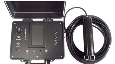
Enhancing Marine Operations: Insights from Industry Reports on the DIVER 101 Vessel-mounted Communication & Positioning System
In the realm of marine operations, the ability to maintain seamless communication and accurate positioning is crucial for the success and safety of underwater missions. The DIVER 101 vessel-mounted communication and positioning system stands at the forefront of this technological advancement, specifically designed to facilitate real-time data sharing among divers, command vessels, and on-shore teams. This integrated system enables divers to receive precise location information while enhancing the situational awareness of the command center, making it an essential tool for modern amphibious operations and subaquatic activities.
By serving as the core command hub, the system plays a pivotal role in coordinating various aspects of marine operations. It ensures that all team members are aware of each other's locations, which is critical in environments that can often become disorienting and hazardous. The DIVER 101 enhances mission efficiency and personnel safety, supporting a collaborative effort that allows for more dynamic and well-coordinated underwater tasks. As industries increasingly rely on advanced technology to streamline operations, the DIVER 101 system exemplifies how innovation can transform traditional practices into more effective and secure methodologies.
FAQS
: Key specifications include accuracy (position and velocity), update rate, and environmental compensation features. High-performance INS can provide position accuracy within 1-2 meters and should have an update rate between 10 Hz and 100 Hz.
Accuracy is essential for navigation precision and reliability, particularly in applications such as underwater exploration and autonomous vessel operations. Higher accuracy enables better decision-making and safer operations on the water.
The optimal update rate ranges from 10 Hz to 100 Hz, depending on operational requirements. A higher update rate allows for real-time adjustments and improved handling of dynamic marine environments.
Environmental compensation minimizes errors caused by factors like temperature variations and vessel motions, which can significantly impact navigation accuracy and reliability.
It’s important to prioritize built-in redundancy for continuous operation and advanced integration capabilities for compatibility with existing marine platforms and navigational aids.
Key cost factors include the initial purchase price, ongoing maintenance and operational costs, calibration, software updates, repairs, and training costs for crew members.
To avoid overspending, align the expected functionalities of the system with your operational requirements, ensuring you choose only the necessary features relevant to your needs.
Ongoing costs should include maintenance, calibration, software updates, potential repairs, and training for crew members who will operate the system.
Training costs are essential for ensuring crew members are well-equipped to operate the system effectively, which contributes to the overall success and efficiency of marine navigation operations.
Conclusion
Choosing the right Marine Inertial Navigation System (INS) is crucial for efficient maritime operations. Several factors influence this selection, including understanding the various types of inertial navigation technologies available, which can vary significantly in terms of specifications and performance metrics. The accuracy of these systems can be significantly impacted by environmental conditions, making it essential to consider how external factors, such as weather and sea state, affect navigation precision.
Additionally, the integration of INS with other navigation technologies enhances overall functionality, providing a comprehensive navigation solution. Budgeting for these systems is also a critical consideration, as costs can vary widely depending on the required features and capabilities. As we look towards the future, innovations in marine inertial navigation systems are expected to emerge, promising advanced functionalities and improved accuracy, thereby paving the way for enhanced maritime navigation.
 TBSD60
 BSD120
 BSD98
BSD98 BSD70
BSD70 BSD60
BSD60 BSD50
BSD50 BSD217
 INS1700
 INS970
 INS570
 INS170
 SLA-4B1L1-65
 SLA-4B1L1-130
 SLA-8B1L1-165
 DIVER 101
 DIVER 102
 DIVER 103
 DIVER 104
 DIVER 105
 DIVER 106
 SLLR3000
 SLLR905
 SLLD25
 160M
160M 170M
170M SLFC-70
 SLAF280
 MR360
MR360